Friday, August 22, 2008

Old Pup was my best friend


Manuel Hastings remembers his childhood in New Mexico where his parents homesteaded in 1929.


“Someone had given us a dog. It was reddish brown with white legs and stomach with a brown and white tail . . . Since we got him as a pup, that name stuck with him as long as we had him. He was referred to as “Old Pup.” I dearly loved this dog and everywhere I went, he would go with me whether I walked or was riding a horse. He would be with me and continually stayed within a few yards of me while hunting. He would often tree a porcupine. At first he would bite at them and get quills in his mouth. We would have to pull them out with pliers. It would hurt so badly, he would almost want to bite at us. But he knew it had to de done.”

Links
Wind Cave National Park--Porcupine - Erethizon dorsatum

Saturday, August 16, 2008

Fire and the Restoration of Homestead NM Grass Prairies


Before Americans of European descent settled on the Great Plains fire would have periodically occurred in the woodlands area that is now part of Homestead National Monument (NM) of America. The woodlands of the Monument would have had a much different composition and look than they do today as the “tall grass prairies once covered 140 million acres of North America. [but] Farming, urbanization, and invasive plant species have reduced this ecosystem to 1% of its original range” (NPS Fire and Aviation Program).

Management of Homestead NM would, if possible, like to return the woodlands to their pre-settlement composition and look. An example of this fire management can bee seen at:


Homestead National Monument of America Presentation - FLASH
An interactive story of maintaining the tall grass prairie in Nebraska through prescribed fire.

To help obtain this goal the Homestead National Monument of America is conducting a hydrology project for Cub Creek and the woodlands surrounding Cub Creek with the aide and assistance of the Great Lakes Northern Forest CESU and Michigan Technological University of Houghton, Michigan. The primary focus of the project is to determine where the trees in the woodlands acquire their water. This will be completed by comparing the different oxygen isotopes found in the rainwater, ground water, soil moisture, and creek water to what is in the cambium of bur oak trees. Three sites in the woodland will be monitored. One of the ultimate goals is to determine the feasibility of re-introducing fire into the woodlands; therefore this project is very important in determining the feasibility of the re-introduction of fire.

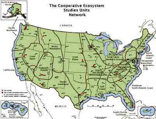
A Homestead NM partner in this venture is the Cooperative Ecosystem Studies Units (CESU) National Network. CESU is a network of collaborative units established to provide research, technical assistance, and education to resource and environmental managers responsible for federal land management, environmental, and research agencies and their potential partners

“Cooperative” emphasizes that multiple federal agencies and universities are among the partners in this program. “Ecosystem Studies” involves the biological, physical, social, and cultural sciences needed to address resource issues and interdisciplinary problem solving at multiple scales and in an ecosystem context. The resources studied encompass both natural and cultural assets.

Homestead National Monument of America is located within the boundary of the Great Plains CESU. The Great Plains CESU is administered by the University of Nebraska-Lincoln. However to complete its needed projects Homestead NM of America can work with any research university in the Great Plains CESU or any research university in another CESU.


Links to the Cooperative Ecosystem Studies Units (CESU) National Network


Saturday, August 9, 2008

The Homestead Honeymooner Highway


For our honeymoon trip… let’s go find a homestead…let’s hope our honeymooner’s were well matched as they made their way through the 1,488 miles of the Alaska Highway. First know as the Alcan Highway this meandering road stretches from Dawson Creek in British Columbia through the Canadian Yukon into Alaska ending at Delta Junction just south of Fairbanks. Known as the last frontier of homesteading, 3,277 homesteads were built on 363,775 acres or about 1% of Alaska’s total state acreage until 1986. (As illustrated on this map of Alaska located on the walkway of the Heritage Center at Homestead National Monument).

In the January 24, 2007 edition of the Anchorage Daily News, we learn about two modern day homesteader honeymooners, Robert W. Brown and Alpha Mae Harrison. Mr. Brown “joined the U.S. Army for a chance to come to Alaska in 1948. On April 15, 1952, Bob traveled back to New Mexico and married his best friend’s sister and childhood sweetheart, Alpha Mae. They spent their honeymoon driving the newly constructed Alaska Highway to Alaska. They settled in the East Anchorage home site area, building many East Anchorage roads and maintaining them for years. Bob and Alpha built two East Anchorage homes and homesteaded in the Big Lake area in 1962. Bob cleared land for many of the Big Lake and Willow homesteaders.”

While it does not seem very romantic to go and find a homestead during a honeymoon it has been done. We see here again the very practical and focused mind of the homesteaders!

For additional stories on the Alaska Highway see:

Recreational Resources of the Alaska Highway and Other Roads in Alaska
http://www.nps.gov/history/history/online_books/alaska/

The Alaska Highway A Yukon Perspective
http://www.alaskahighwayarchives.ca/en/index.php

Driving the Alaska Highway: It's still a great adventure
http://www.outwestnewspaper.com/akhwy.html

Alaska Highway Photo Album
http://www.explorenorth.com/library/weekly/aa111398.htm